About Il Sentiero delle Orobie
From the experience of the journal Nature, culture and tradition OROBIE, it founded the eponymous series of applications for mobile devices, designed to provide useful information to all mountain lovers, sports and...
From the experience of the journal Nature, culture and tradition OROBIE, it founded the eponymous series of applications for mobile devices, designed to provide useful information to all mountain lovers, sports and leisure.
The app dedicated to TRAIL OROBIE accompanies you to discover one of the most interesting hiking trails, scenic and organized in the Alps. With maps, data sheets, elevation profiles and GPS tracks.
From now you can access free of charge to all 14 stages of the Path, with descriptions and maps of the guide.
The maps and the cards can be used offline.
The functionality and the main contents:
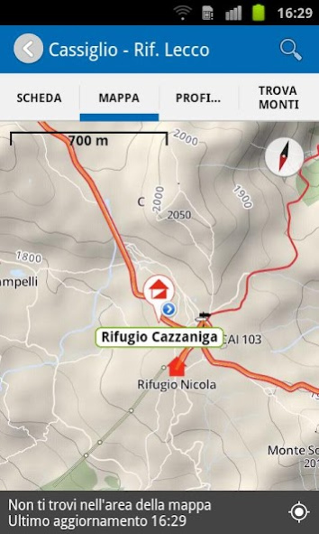
- The routes of the trail and access with the tracks CAI and maps created especially for the series Orobie with Open Street Map data and altitude NASA, completely off-line for use without internet connection.
- And comprehensive summaries of each stage of the Path of Orobie; with a touch switches to display on map of points of interest are described.
- The list of Lee Path Orobie with e-mail and telephone contacts.
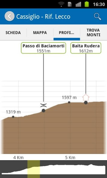
- Extraordinary elevation profiles with the GPS position of the hiker even in places not covered by the telephone network.
- An overview of more than 500 peaks that occur orobiche skyline.
- Research to find on the map the peaks, the steps, the shelters, the locations and other points of interest of the Path.
We work constantly to improve the quality of the experience with our app. We are very interested to have your opinion and suggestions. Write to www.midapp.it section support.
WARNINGS
Traces CAI: the data are not the result of a survey of GPS accuracy, but in part have been digitized using as a reference and background cartography CAI, regional, IGM and orthophotos. There is no warranty on the accuracy or the accuracy of the coordinates, therefore, whoever it discovers anomalies, errors, inaccuracies or other problems in the data is kindly asked to notify the CAI, which will verify the alert.
The stages of the Paths Orobie in this app are be attended season in late spring - summer when the shelters are open and the conditions of the trails are hiking in nature. In other seasons the conditions (presence of snow and / or ice) make such paths much greater difficulty suitable for experienced mountaineers with winter equipment.
Smartphones are not safety devices. The functionality of the app depends on the reception of the GPS and the accuracy of the compass of the mobile device.
Previous Versions
Here you can find the changelog of Il Sentiero delle Orobie since it was posted on our website on 2023-03-05 12:59:32.
The latest version is 1.5 and it was updated on 2024-04-22 18:24:20. See below the changes in each version.
Il Sentiero delle Orobie version 1.5
Updated At: 2015-05-06
Changes: L'App è ora completamente gratuita!
Disclaimer
Official Google Play Link
We do not host Il Sentiero delle Orobie on our servers. We did not scan it for viruses, adware, spyware or other type of malware. This app is hosted by Google and passed their terms and conditions to be listed there. We recommend caution when installing it.
The Google Play link for Il Sentiero delle Orobie is provided to you by apps112.com without any warranties, representations or guarantees of any kind, so access it at your own risk.
If you have questions regarding this particular app contact the publisher directly. For questions about the functionalities of apps112.com contact us.